
How Sensors, Mapping, and Messaging Improve Flood Readiness
In Botetourt County, Virginia, land use is changing fast. Farmland in the north is giving way to suburban development in the south, altering how water moves across the landscape. Fields that once absorbed heavy rain now shed runoff toward neighborhoods and roads built for another era.
After Hurricane Helene and several intense pop-up storms, the county partnered with FloodMapp, Green Stream Technologies, and The Warn Room to launch an impact-based early flood warning system.
Building the system, step by step
Botetourt County followed a clear sequence:
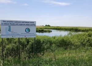
- Sensors first. New Green Stream Technologies gauges were installed at known trouble spots, likely future hotspots, and key outfalls.
- Maps second. FloodMapp converts live sensor data into real-time inundation maps and short-term forecasts showing depth and extent.
- Outreach third. The Warn Room supports targeted alerts layered onto the county’s mass-notification system, ensuring residents hear from one trusted source.
This order matters. Ground-truth data from creeks and culverts provides a clearer picture than relying on a single river gauge, especially as flash flooding increasingly comes from localized storm cells.
What changes during a storm
The system enables earlier staging of response teams, clearer public messaging tied to specific roads or neighborhoods, and stronger after-action reviews. Depth and extent data support future grant applications, justify culvert upgrades, and refine response plans.
While the system is new and has not yet produced dramatic rescue stories, early outcomes are exactly what readiness should deliver: faster decisions, shared situational awareness, and better evidence for future investment.
Lessons for peer communities
- Place gauges where problems start. Use historical complaints, new development patterns, and hydrology to guide placement.
- Let data drive decisions. Tie staffing and alerts to objective thresholds.
- Build messaging on top of instrumentation. Sensor-based alerts are more credible and actionable.
AFC highlights initiatives like Botetourt County’s to foster peer learning and accelerate the adoption of practical flood resilience tools. Over time, the county will integrate this system with culvert upgrades, green infrastructure, and roadway protection.
“Sensors first, then maps, then messaging. Real-time data turns urgency into smart decisions,” said Botetourt County Emergency Manager Daniel Murray.